GEOTECHNICAL ENGINEERING
EUGENE OREGON
HomeSeismicSeismic microzonation

Seismic Microzonation Studies in Eugene, Oregon

Geotechnical engineering with regional judgment.

LEARN MORE

A seismic microzonation study in Eugene starts with a set of triaxial geophones and a 24-channel seismograph. We set up a linear array across the site, hammer a steel plate, and record the surface waves that travel through the valley alluvium and weathered sandstone beneath the grass seed fields. The equipment captures shear-wave velocity profiles down to 30 meters—that VS30 number that determines your Site Class per ASCE 7. Around the Willamette Valley, the contrast between young floodplain silts and the Eugene Formation sandstone can shift a site from Class D to Class C within a hundred feet. Because the city sits on a complex mix of Holocene alluvium and Tertiary marine sediments, we often combine the MASW line with a few SPT borings to tie the geophysical readings to actual soil descriptions and blow counts. The seismograph data feeds into a 1D site response model, which generates the design acceleration spectra you need for structural engineering.

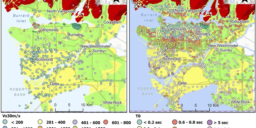
VS30 is not a number you pull from a county map. It changes within a single Eugene block when the alluvium thins over the Eugene Formation.

Our service areas

Scope of work

Drive from the sandy, well-drained soils on the south side of town near Spencer Butte over to the silty, high-plasticity clays along the Willamette River in the Whiteaker neighborhood, and you will see why Eugene demands microzonation. On the butte slopes, weathered Eugene Formation rock yields VS30 values above 500 m/s, often classifying as Site Class C. Down in the flatlands, ten feet of soft organic silt over thirty feet of loose alluvial sand can drop VS30 below 200 m/s—firmly Site Class D, sometimes bumping against Site Class E where the water table sits just three feet down in winter. The IBC multiplies your design base shear accordingly, and the difference hits the structural budget hard. Our approach maps these transitions block by block, not just by zip code. We run parallel MASW lines and calibrate the velocity model with index tests from split-spoon samples, so the final map reflects what is actually under the footing, not a regional average.
Seismic Microzonation Studies in Eugene, Oregon
Technical reference — Eugene Oregon

Area-specific notes

One thing we keep seeing in Eugene: a project gets assigned Site Class D from a regional map, but the actual site sits on a thin lens of stiff Pleistocene gravel over soft silt. The owner runs a standard structural design, and five years later the drywall cracks above the door frames. The culprit is often long-period amplification in the soft layer that the generic map missed. A site-specific microzonation catches that. It also flags liquefiable layers—the loose sand lenses in the Willamette floodplain can trigger settlement under a magnitude 9 Cascadia event, even if the surface looks dry in August. Without the velocity profile and the calibrated ground model, you are designing for the wrong acceleration spectrum, and the code does not forgive that. The Oregon Structural Specialty Code (OSSC) enforces IBC Chapter 16 with local amendments, and having a stamped microzonation report puts your geotechnical assumptions on solid ground.

Need a geotechnical assessment?

Reply within 24h.

Email: contact@geotechnical-engineering.vip

Watch how it works

Standards used

ASCE/SEI 7-22 Minimum Design Loads and Associated Criteria for Buildings and Other Structures, 2022 Oregon Structural Specialty Code (OSSC), adopting IBC 2021 with state amendments, ASTM D4428/D4428M-07 Standard Test Methods for Crosshole Seismic Testing (for crosshole calibration where applicable), NEHRP Recommended Seismic Provisions for New Buildings and Other Structures (FEMA P-2082), ASCE 7-22 Section 20 Site Classification Procedure

Technical parameters

ParameterTypical value
Target depth30 m (100 ft) per IBC/ASCE 7
Primary methodMASW (active-source, 24-channel)
Computed parameterVS30 (shear-wave velocity, top 30 m)
Site class outputIBC/ASCE 7 Site Class A through F
Spectral accelerationS_S, S_1 from USGS + site coefficients F_a, F_v
Calibration dataSPT N-values, soil unit weight
Reporting standardOSSC 2022 / ASCE 7-22 Section 20

Common questions

Does the City of Eugene require a seismic microzonation for a standard commercial building?

Not for every building. The Eugene building department follows OSSC/IBC, which triggers site-specific ground motion analysis for Site Class F sites and for structures assigned to Risk Category IV where long-period amplification is a concern. In practice, we see microzonation requested most often for essential facilities, three-story-plus structures on soft soils, and any project where the geotechnical engineer flags a possible Site Class E or F condition. A call to the city plans examiner early in the project will clarify whether your parcel requires it.

How much does a seismic microzonation study cost for a typical Eugene lot?

For a standard commercial lot in Eugene, the field acquisition, processing, and reporting typically range from US$4,320 to US$16,920. The spread depends on the number of MASW lines, the need for supplementary borings to calibrate the velocity model, and whether the scope includes a full site response analysis versus a simple VS30 determination. We can give you a firm number once we see the site geometry and the geotechnical report from the boring program.

How long does it take to get the final microzonation report after the field work?

Field work usually takes one day per MASW line. After that, we spend five to eight business days on processing the dispersion curves, inverting the velocity profiles, and drafting the report. If we need to wait for lab results from companion borings—like Atterberg limits or unit weight—add a few extra days. Most Eugene projects go from field kickoff to stamped PDF in under three weeks.

Location and service area

We serve projects across Eugene Oregon and its metropolitan area.

View larger map