GEOTECHNICAL ENGINEERING
EUGENE OREGON
HomeSlopes & WallsSlope stability analysis

Slope Stability Analysis in Eugene Oregon: Hillside Construction & Landslide Risk

Geotechnical engineering with regional judgment.

LEARN MORE

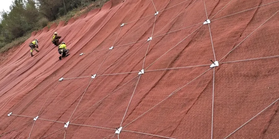
Drive from the flat grid streets of the Whitaker neighborhood up toward the winding lanes of the South Hills, and you'll feel the ground change within a mile. The valley floor near the Willamette River sits on soft alluvial silts that barely hold a 2:1 cut, while the hillside lots south of Spencer Butte sit on weathered sandstone and claystone that can stand steep—until winter rains saturate the upper few feet and everything wants to slump toward Amazon Creek. That contrast is why a proper slope stability analysis in Eugene rarely looks like a textbook exercise. The Willamette Valley's wet winters, combined with thin colluvial soils over weathered bedrock, create conditions where even a modest cut for a driveway can trigger a shallow translational slide. Our work across the metro area has taught us that the first step isn't running software—it's walking the slope after a February rain and seeing where the water's moving. Before committing to a hillside build, pairing the slope evaluation with test pits to map the colluvium-bedrock contact gives you a stratigraphic baseline that no desktop study can replicate.

A slope that drains well in July can fail in February—not because the soil changed, but because the pore pressure did.

Our service areas

Scope of work

Eugene sits at roughly 430 feet above sea level, but the elevation range across the city—from the river at about 380 feet to the South Hills cresting above 1,500—creates microclimates that directly affect slope stability. The upper hills receive 15 to 20 percent more rainfall annually than the valley floor, and most of that arrives between November and March when evapotranspiration is near zero. That seasonal loading is what we see driving the majority of local slope failures: pore pressure builds at the soil-bedrock interface, effective stress drops, and a colluvial blanket that seemed perfectly stable in August starts creeping by January. Our approach to slope stability analysis follows the FHWA-NHI-05 framework for soil and rock slopes, but we adapt it with site-specific shear strength testing from undisturbed samples rather than relying on generic correlations. In the Spencer Butte area, where residual clay soils can have cohesion values below 200 psf when saturated, that distinction matters enormously. We also run limit-equilibrium analyses under both static and pseudo-static conditions per the Eugene building code's adoption of ASCE 7 Chapter 15, because the Cascadia Subduction Zone doesn't care about your setback line.
Slope Stability Analysis in Eugene Oregon: Hillside Construction & Landslide Risk
Technical reference — Eugene Oregon

Area-specific notes

In Eugene, the slope failures we investigate most often aren't the dramatic landslides that make the evening news. They're the slow-creep failures that crack a foundation wall over three winters, or the shallow slumps that take out a backyard retaining wall and half the rhododendron bed. The common thread is almost always water. The weathered sandstone and claystone bedrock beneath the South Hills has a permeability contrast with the overlying colluvium that traps groundwater at the contact, creating a natural slip surface. Homeowners who skip a slope stability analysis sometimes discover this after they've already cut into the hillside for a daylight basement and changed the groundwater flow path. What makes Eugene different from drier parts of Oregon is the sustained wet season—five months of near-constant soil saturation means that a slope doesn't get a chance to drain and recover between storms. That accumulation effect shows up in our factor-of-safety calculations as a progressive reduction that can push a 1.3 static FoS below 1.0 by March if drainage isn't designed into the slope from the start.

Need a geotechnical assessment?

Reply within 24h.

Email: contact@geotechnical-engineering.vip

Standards used

FHWA-NHI-05-123: Soil Slope and Embankment Design, ASCE 7-22 Chapter 15: Seismic Design Requirements for Slopes, IBC 2021 Section 1803.5: Foundation and slope investigations, ASTM D3080/D3080M: Direct Shear Test of Soils Under Consolidated Drained Conditions, ASTM D4767: Consolidated Undrained Triaxial Compression Test for Cohesive Soils, ODOT Geotechnical Design Manual (2020): Slope stability design criteria

Technical parameters

ParameterTypical value
Analysis methodsLimit equilibrium (LEM), finite element (FEM), kinematic (rock)
Failure modes evaluatedRotational, translational, compound, wedge, toppling
Seismic coefficient (kh)Per ASCE 7 site class, typically 0.10–0.18 for Eugene
Minimum FoS (static)1.5 (permanent slopes), 1.3 (temporary cuts)
Minimum FoS (seismic)1.1 (pseudo-static per IBC 2021)
Soil shear strength inputsDirect shear (ASTM D3080) or triaxial (ASTM D4767)
Groundwater modelingSteady-state and transient seepage (SEEP/W or equivalent)
Typical deliverableStability report with cross-sections, FoS tables, and reinforcement recommendations

Common questions

How much does a slope stability analysis cost for a residential hillside lot in Eugene?

For a typical single-family residential hillside parcel in the Eugene area, a slope stability analysis with field investigation, laboratory testing, and a signed engineering report generally falls between US$1,310 and US$3,980. The range depends on slope height, access for drilling equipment, and whether groundwater monitoring wells need to be installed. Steep lots in the South Hills with limited access tend toward the upper end.

Does Eugene require a slope stability report for building on a hillside?

The City of Eugene and Lane County both have hillside development overlays that trigger geotechnical review requirements. Generally, if your lot has slopes steeper than 25 percent or is within a mapped landslide hazard zone, you will need a slope stability analysis signed by a licensed geotechnical engineer as part of your building permit application. The report must address both static and seismic stability per the adopted IBC and ASCE 7 standards.

How long does a slope stability study take from start to finish in the Willamette Valley?

A complete slope stability study in the Eugene area typically takes three to five weeks from authorization to final report. The timeline breaks down as roughly one week for field exploration and sampling, two weeks for laboratory shear strength testing, and one to two weeks for analysis and report preparation. Winter field work can add time if saturated conditions prevent safe drilling access on steep slopes.

Location and service area

We serve projects across Eugene Oregon and its metropolitan area.

View larger map